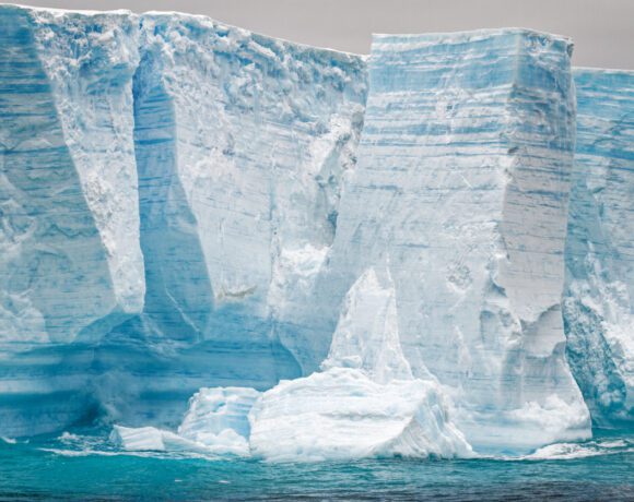

A towering face of Antarctic ice can make the familiar world feel suddenly incomplete. From a small vessel, the scale is difficult to judge. The white surface stretches beyond the frame, and the land behind it may be invisible. It is an extraordinary sight. It is also an invitation to ask a precise question: what does this image actually establish?
The phrase “ice wall” can describe the appearance of a real coastal ice cliff. In some online narratives, however, it carries a much larger claim: that Antarctica conceals the boundary of our world or territory excluded from conventional maps. Those propositions require different kinds of evidence. A photograph of an ice face supports the existence of that ice face. It does not establish a hidden geography.
For readers interested in unexplained places, this distinction is useful rather than limiting. Antarctica contains genuine scientific unknowns. Understanding what has been measured makes those unknowns more interesting, and helps separate discovery from an interpretation attached to dramatic footage.
The accompanying selection from The Why Files provides a broader Antarctic-mysteries context for this exploration. The focus here is narrower: how to assess the ice-wall idea against documented geography. The article does not treat the video's selection as evidence for that idea or attribute a specific ice-wall argument to its presenter. [Video]
How an ice cliff forms
Antarctic ice is not one uniform structure. The Australian Antarctic Program explains that ice shelves form where continental ice flows toward the coast and extends over the ocean. The floating shelf remains connected to ice on land, and pieces can break away to become icebergs. Seen from the water, its front can resemble an immense wall. [1]
The important distinction is between the visible edge and the entire system. An ice shelf is a moving extension of a glacier or ice sheet. It is not evidence of a constructed barrier. Its shape reflects the supply of ice, interaction with the ocean, and the loss of material through processes including calving. [1]
Sea ice is another category. The National Snow and Ice Data Center distinguishes floating extensions of land ice from ice produced when seawater freezes. Confusing those categories can turn ordinary descriptions of changing coastal conditions into apparent contradictions. A report about sea ice and an image of a thick ice shelf may concern different physical features. [2]
Before interpreting any spectacular clip, look for its location, date, and original source. Does the camera show an ice shelf, a glacier front, or an iceberg? Has the uploader identified the feature, or only supplied a suggestive caption? When those details are missing, uncertainty belongs in the interpretation. It should not be replaced by confidence that the footage reveals something the footage cannot demonstrate.
What lies beneath the white surface
Antarctica's concealed landscape is a real subject of research. In 2025, scientists published Bedmap3, an updated compilation describing the continent's surface, ice thickness, and underlying bed. The project added 84 aerogeophysical surveys from 15 data providers to earlier datasets, incorporating an additional 52 million data points. [3]
Those measurements help describe mountains, basins, and other features that cannot simply be photographed through the ice. They also show why a scientific map should be read with attention to its methods. A compiled dataset brings observations together; it is not a promise that every square metre has been directly inspected. Better survey coverage can improve a map without suggesting that earlier researchers deliberately concealed terrain. [3]
An honest account leaves room for revision. If a new survey changes an estimate of ice thickness or clarifies a valley, the useful questions concern how the measurement was made, its uncertainty, and whether independent observations support it. Calling every revision a cover-up makes a theory difficult to test: agreement becomes suspicious, while correction becomes suspicious too.
The more demanding approach asks an alternative claim to make a prediction. Where exactly is the proposed boundary? What coordinates describe it? What observations would distinguish it from a mapped ice shelf? Without answers, “beyond the wall” remains a story with an undefined destination.
Does the Antarctic Treaty prohibit discovery
Antarctica's unusual governance is often folded into claims about secrecy. The actual Antarctic Treaty is available to read. Its provisions include peaceful use, freedom of scientific investigation, and exchange of scientific observations and results. Article VII provides an inspection framework. These are features of a published agreement, not evidence of a treaty designed to establish an undisclosed geographical boundary. [4]
Inspection rights under the treaty should not be confused with unrestricted access for every individual. The existence of an official inspection system does not mean a visitor can enter any station or travel anywhere without arrangements. Equally, a restriction on a particular journey does not, by itself, identify what someone imagines is being hidden.
These distinctions matter because the argument can otherwise change halfway through. “This expedition needs authorization” is a claim about an activity and its rules. “Nobody is allowed to visit Antarctica” is a much broader claim. The second does not follow from the first.
The Antarctic Treaty Secretariat documents tourism and nongovernmental activity, including vessel-based visits, air-based travel, and deep-field tourism. It also publishes guidance and describes reporting requirements. That record contradicts a blanket claim that civilian visitors are excluded from the continent. It does not imply that access is simple, universal, or free of environmental responsibilities. [5]
Regulation deserves scrutiny on its own terms. Readers can ask whether a rule is proportionate, how decisions are made, and what evidence supports a restriction. Those are answerable questions. Treating every rule as proof of a secret replaces investigation with a conclusion already chosen.
Watching extraordinary claims carefully
A useful viewing habit is to separate three layers: what the camera records, what the narrator says, and what the viewer infers. Those layers can align, but they should never be assumed to be identical. A narrator may be offering a possibility rather than reporting a finding. An editor may juxtapose unrelated scenes. A translated subtitle may express uncertainty differently from the spoken language.
Before quoting a presenter, check the actual wording in context and preserve its timestamp. A title or promotional description cannot establish everything said in a programme. A host may recount a theory before questioning it later. Without checking that full context, a specific attribution can misrepresent the discussion even when the quoted words are accurate.
The same discipline applies to maps and documents shown briefly on screen. Find the full document, identify who produced it, and read the surrounding passage. A cropped map can omit its legend; a historical proposal can be presented as an adopted policy. Neither problem is solved by the confidence of the narration.
Curiosity does not require equal confidence in every explanation. A claim supported by reproducible measurements deserves more weight than one supported by an unnamed source or an unexplained image. That judgment can change when better evidence arrives, but the possibility of future evidence is not evidence already in hand.
A more useful mystery
Antarctica does not need an invented edge of the world to be remarkable. Its ice conceals landscapes researchers are still resolving, and its changing margins raise practical scientific questions. The strongest reason to keep investigating is that careful measurement can tell us something we did not know before.
The ice-wall story is worth examining as a claim, not accepting as a discovery. Ask where an image came from. Read the treaty rather than a caption about it. Compare an interpretation with the measurements it would need to explain. An open mind is most useful when it remains willing to reject an attractive story that has not earned its conclusion.